Skip to contentInformation for people with disabilityInformation on accessibility

This chapter outlines the Redistribution Committee's proposed redistribution and the reasons for this proposal. Also included is the Redistribution Committee's approach to formulating the proposed names and proposed boundaries of proposed electoral divisions.
Figure F: Comparison of current and proposed electoral division boundaries
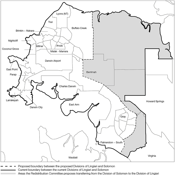
Note: This map shows selected SA2s of the Northern Territory.
Description of proposed boundary: At its most northerly point, the proposed boundary starts at the Northern Territory coast and follows the border between the Darwin Municipality and the Litchfield Municipality to the intersection of McMillans Road and Vanderlin Road. The proposed boundary continues to follow the border between the Darwin and Litchfield Municipalities along Vanderlin Drive in a southerly direction to the intersection of Vanderlin Drive and the Stuart Highway.
The proposed boundary continues following the border between the Darwin and Litchfield Municipalities, and the Palmerston and Litchfield Municipalities in a south-easterly direction along the Stuart Highway to the intersection with the suburb of Yarrawonga. From this point, the proposed boundary follows the eastern border of the suburbs of Palmerston City, Gunn, Bakewell (which follows Roystonea Avenue with the exception of the north-eastern corner of the suburb of Gunn when the suburb border deviates from Roystonea Avenue), Rosebery and Bellamack to Channel Island Road.
The proposed boundary follows Channel Island Road in a southerly direction to the Elizabeth River. At this point, the proposed boundary follows the Elizabeth River in a north-westerly direction to the coast, and then follows the coast in a clockwise direction to the point at which the Darwin and Litchfield Municipality borders meet the coast.
Figure G: Proposed Divisions of Lingiari and Solomon – enrolment as at Thursday 15 October 2015, current enrolment quota and permissible range of electors
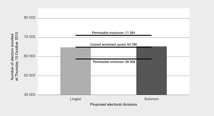
Source: Available from www.aec.gov.au/nt-redistribution
Figure H: Proposed Divisions of Lingiari and Solomon – projected enrolment as at Friday 7 August 2020, projected enrolment quota and permissible range of electors
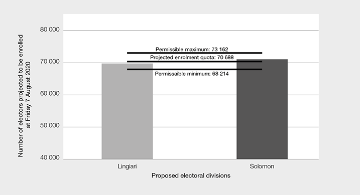
Source: Available from www.aec.gov.au/nt-redistribution
| Number | Percentage | |
|---|---|---|
| Electors transferred to another electoral division | 2 680 | 2.07% |
| Electors remaining in their existing electoral division | 126 891 | 97.93% |
| Total | 129 571 | 100.00% |
| Proposed electoral division | Enrolment as at Thursday 15 October 2015 | Projected enrolment as at Friday 7 August 2020 | Approximate area | ||
|---|---|---|---|---|---|
| Number | Percentage variation from the current enrolment quota | Number | Percentage variation from the projected enrolment quota | ||
| Lingiari | 64 552 | -0.36% | 69 914 | -1.09% | 1 348 157.94 km2 |
| Solomon | 65 019 | 0.36% | 71 462 | 1.09% | 190.61 km2 |
| Total | 129 571 | 141 376 | |||
The AEC acknowledges the Traditional Owners of Country throughout Australia and recognises their continuing connection to land, waters, culture and community. We pay our respects to Elders past, present and emerging.